Tuesday, November 17, 2009

Chilliwack Landslide Moves Homes

Most people think of landslides as violent mountain slope events but there is another type that threatens property owners. Geologists call them "big slow movers." These underground land masses can move of their own accord but generally they are prodded into action by changes in the landscape. Case in point: Panorama Heights/ Marble Hill “Big Slow Mover”—City of Chilliwack, British Columbia.

The media reports that 42 existing subdivision homes are threatened by the creeping 4,000 year-old Panorama Heights landslide—3 others were so damaged that they have been razed.

Here is a description of the landslide damage caused to one Panorama Heights home:
Eleven years ago, Dixon had a few cracks to worry about, but now, his house is like something you’d see in an animated Tim Burton movie. The exterior brick walls are pulling and crumbling away from the foundation, the windows are crooked, the carport cement has pulled away from the house, and the steps up to the front door have inched down so far, Dixon had to put in two more steps just to get into his house. Some of his doors fly open at a whim, while others won’t even close half way, the floors are all on a slope, forcing him to walk uphill or downhill, but never on level.


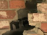
Gary Dixon's Panorama Heights home—
Photos and news report compliments Chilliwack Progress

Restitution

On October 10, 2009 the Vancouver Sun reported that the City of Chilliwack has offered Panorama Heights homeowners an $18 million purchase plan ( 80% of current assessed value) as compensation for loss of equity and property damage. The offer is extended to Panorama Drive, Ridgeview Street, Ridgeview Place and Allison Place property owners.

Looking Back

Twelve years ago, six Panorama Heights landslide-affected property owners sued the city. In 2006 five plaintiffs agreed to confidentially settle the matter. By searching land title transfers the Chilliwack Progress determined that the city paid $951, 500 for three of the homes at issue in the lawsuit.

Landslide concerns prompted the Chilliwack City Council to pass a 6-month Eastern Hillsides no-build moratorium on September 13, 2004. Reassured by engineering reports, council members rescinded the suspension on October 1, 2004. The moratorium remained in place for the Panorama Heights subdivision.

Mayor Sharon Gaetz has stated that she does not believe the planning department is at fault for granting the Panorama Heights subdivision permit.

Geology Lesson

Garry Taylor, a Chilliwack high school geology teacher, disagrees:
A resource I have used in my classroom to teach my students is a Geological Survey Map of Canada (printed in 1977) that I obtained from the federal government, which is also available to the pubic.

My students are taught that the present site of Panorama Heights sits squarely on this 4,000-year slide site. With this type of information readily available, they find it confusing as to why this development was given the green light to go ahead. Perhaps somebody with the former geo-tech company who did the original stability assessment, or the party who signed off this development at city hall, missed a very important lesson.
City of Chilliwack Hazardous-Land Real Estate Disclosure Statement

Panorama Heights property owners have been ill-served by the city's past actions. If the city elects to continue permitting hazardous-land subdivisions they have an obligation to inform future property owners of the financial risks. Real Estate transactions should include the following fair warning disclosure statement:
Please be advised that you are buying real estate in a critical landslide area.

The decision to buy landslide-hazardous real estate should be well-considered. Flood and fire insurance is available to property owners. Landslide insurance protection is not obtainable. The inability to insure this special-risk real estate will have an adverse effect on property values and mortgage refinancing. Please seek legal advice concerning landslide liability.
Landslides are multi-province concerns but, "In fact, in British Columbia the loss of life and damage to property caused by landslides is greater than losses caused by other natural hazards such as earthquakes and flooding." Findings: Ministry of Energy, Mines and Petroleum Resources

Sunday, November 15, 2009

Spanish Peaks Hazardous-Land Report Prompts Two Lawsuits

The Spanish Peaks lawsuits provide invaluable information.

Terrence O’Reilly: Plaintiff

The individual who brought suit, a former employee and property owner of The Club at Spanish Peaks, alleged that the developer had withheld unfavorable geology reports. The case was filed in Gallatin County, Montana in 2007 and confidentially settled in 2009.

New West Bozeman investigative reporters, Elizabeth Diehl and Megan McLean, offer a look at the documents submitted in the O’Reilly Complaint in their August 10, 2009 article “Spanish Peaks Lawsuit Alleges Deception on Landslide Risk.”

The Club at Spanish Peaks Hazardous-Land Report

Court records show that as part of Spanish Peaks approval process subdivision home sites were evaluated for hazardous-land conditions. In March 2000 NTL Engineering and Geoscience, Inc. provided the developer, James Dolan, with a “geotechnical reconnaissance report.“ Each lot was color-coded to reflect the risk of landslides and unstable soils. Spanish Peaks lot sales were initiated in 2004.

Behind the Scenes

Emails procured during the discovery process reveal the company's unwillingness to share the NTL report with prospective clients.

In a February 2004 email exchange between company executives the question is posed: “Soil tests and stability seem to be coming up pretty regularly with potential buyers. Any suggestions on how to handle this based on your past experiences?”

The reply: “With regard to geotechnical stability, this seems to be one of those areas where we should baffle them with BS rather than provide the actual report.”

Sales continued for the next two years with the developer remaining silent about the subdivision’s hazardous-land report. In another email the NTL report is discussed again:
Any interim report would open the lodge and settlement to scrutiny. The more information in the public eye today may only cause additional and unnecessary concern in the public that will leak its way into the real estate community and the approval process.”
Harbaugh Lawsuit

The evidential NTL report is the issue in another lawsuit filed against the Spanish Peaks developer. According to allegations in the August 2009 Gallatin County District Court Complaint, the developer failed to disclose that lots were sold on an “active landslide.”

If there is a moving landslide inside the subdivision, property owners face incalculable costs: absence of landslide insurance, repair of roads, loss of equity and inability to refinance.

Interstate Land Sales Full Disclosure Act

Although not referenced in the New West Bozeman article, Spanish Peaks property owners have protection under federal law. The Interstate Land Sales Full Disclosure Act, administered through the U. S. Department of Housing and Urban Development, seeks to protect purchasers from fraudulent actions by requiring developers to disclose all material facts affecting the value of land in their subdivisions. Relevant information is conveyed to purchasers via a legal document called the Property Report.

Hazardous-land assessments are material to purchasers and the failure to disclose them would be a violation of the Act.

Wednesday, November 11, 2009

Strike Two—Ocoee Gorge Rockslide Closes U. S. Highway 64


For those who missed the national news, here is the real-time video of the November 10, 2009 Tennessee Ocoee Gorge rockslide.

Since late October, rockslides have closed two primary connectors between western North Carolina and eastern Tennessee. The Pigeon River Gorge I-40 rockslide severed the route between Asheville, North Carolina and Knoxville, Tennessee. The Ocoee Gorge U. S. 64 rockslide blocks access into Cherokee, North Carolina.

Sections of the Blue Ridge Parkway in North Carolina have also been affected by unstable slope conditions.

This season's rockslides have so far only hit public roads. Because memories fade, the news media has not linked current events to those of September 2004. Five years ago rain set off landslides in 15 western North Carolina counties which resulted in two federal disaster declarations. Those wide-spread slope failures claimed lives and cost homeowners millions of dollars in property losses. Caveat: Homeowners nationwide have to self-insure for landslide damage: policies do not cover this peril.

For the usual profit-driven reasons, North Carolina legislators are adverse to publicizing the fact that steep slope home sites and subdivision private streets are threatened by the same conditions that brought down two mountainsides. By intent, conveyance documents such as sales contracts and Subdivision Street Disclosure Statements fail to reveal the high costs of western North Carolina mountain real estate.

I-40 Pigeon River Gorge Rockslides: Past, Present and Forecast

As reported by Vicki Hyatt, editor of The Mountaineer, the Pigeon River Gorge section of I-40 has and will continue to be a rockslide-hazardous corridor. The following is a reprint of her November 3, 2009 article “I-40: A troubled history.”

Rock slides that halt travel between Haywood and Newport, Tenn., have plagued Interstate 40 since it first opened in October 1968. Just four months after the dedication of the route, known early on as the Pigeon River Road, occurred in February 1969, when a slide blocked traffic on all four lanes of the route.

The area near the access road to Waterville Dam was grouted, rock was drilled, dynamited and then filled with liquid cement to halt the earth movement. It was the first of many actions that would be taken through the years to stabilize an area engineers had long warned would pose problems in the future.

In 1974, the pavement again started showing signs of movement, according to an article in The Mountaineer, and it wasn’t unusual for smaller slides to cause periodic delays.

The interstate was closed for two weeks in March 1977 after about 40,000 tons of rock slid onto I-40 about two miles inside the Tennessee state line. At the time, a state geologist noted the area was the site of a major fault with mostly coarse rock which could easily fracture and slide. News reports said geologists were striving to determine if there was one big slide or two separate ones in the area.

In May 1978, a major slide that led to a wreck in which seven people were inured closed the eastbound lanes of I-40 near the Fines Creek exit. The $1 million repair job included work on the cut to prevent future slides and halt slippage of a rock bank near the exit. Two-way traffic was maintained in the westbound lanes during the work, and three people were killed in a head-on collision when slide repairs were underway.

A February 1981 rock slide, about half a mile east of the Tennessee line, covered both the east and westbound lanes of I-40 with boulders, dirt and trees.

The frequent slides made it apparent a longer-term solution was called for, and the state transportation department announced plans to reconstruct four miles of interstate through Haywood County near the Tennessee line to reduce the danger of rock slides. The first phase of the project would shift two lanes of traffic away from the mountainside and toward the Pigeon River, a May 20, 1981 article in The Mountaineer stated. The second phase would remove loose rocks from slopes and take other measures to install wire mesh to catch the rocks before they hit the highway.

Since the roadway opened, two people had been killed as a direct result of falling rocks and another three died in a collision at a landslide detour near the Fines Creek exit, the article noted. At the time, the state’s assistant transportation director said experts believed the possibility of rock slides was of such a magnitude that it could close the road.

In the fall of 1981, a N.C. Department of Transportation report projected $10.3 million — three times the $1.5 million per mile cost to build the roadway — would be needed to reduce the danger of rock slides on I-40 near the Tennessee line. This amount would be enough to correct problems at five potential slide areas, a news article reported. Even with the stabilization work, state officials noted there was no way to stabilize cut slopes entirely.

Before a contract was finalized for the work, a March 1982 slide buried the westbound lanes near the Tennessee line. The project continued into 1984. It included shifting three miles away from the rock slopes and toward the Pigeon River, as well as bolting rocks too large to remove in the five problem areas identified as most susceptible to slides. The project included a chain-link fence to prevent smaller boulders from falling onto the driving lanes.

In March 1985, a massive slide blocked both tunnel entrances. The repair cost about $6 million and nearly a year to clean up.

In July 1997, a massive slide again closed the roadway, taking six months and $2.5 million to clean up.

Road a political victory

Haywood County leaders won a hard-fought battle more than 60 years ago when the county became the last in the state to have a 1921 road law implemented. The law promised a paved roadway linking every county seat and linking every county adjoining another state to that state’s county seat. The long-identified route between Haywood and Newport, Tenn. was a water-level route following the Pigeon River. The route received state funding and was begun five years before it was necessary to designate an interstate route between Knoxville, Asheville and Spartanburg, S.C. The interstate designation, which held the promise of vastly increased commerce — and economic prosperity — was coveted by both Haywood leaders and those in Madison and Buncombe counties, which pushed for a four-lane highway along the French Broad River.

Haywood leaders were able to garner support from the Tennessee Highway Commission, as well as counties to the west. That support, along with free right-of-way along the Pigeon route and a head start on construction, won the prize.

See more pictures of rock slides throughout I-40’s history at www.themountaineer.com.

Tuesday, November 3, 2009

I-40 Rockslide Reveals Western North Carolina Hazardous-Land Conditions


Western North Carolina: I-40 Pigeon River Gorge Rockslides— July 1997 /October 2009 —NCGS & Asheville Citizen-Times

The Pigeon River Gorge I-40 rock slide has shut down a major corridor from Asheville, North Carolina to Knoxville, Tennessee. This mountain side collapse preceded a similar I-40 rock slide in 1997. Professionals estimate remediation will take months and cost millions.

A major landslide also threatens the Blue Ridge Parkway as noted in the following October 16, 2009 Blue Ridge Parkway Update:
With growing fears of a major landslide onto the Blue Ridge Parkway, officials have indefinitely closed a 1.5-mile section of the Parkway near Mt. Pisgah - south of Asheville. Barricades are at the Bad Fork Valley Overlook at milepost 399.7 and the Wash Creek Valley Overlook at milepost 401.1. The closure is a result of widening 300-foot-long fissures on a slope 200 feet above the road. If the 50-foot-deep cracks cause a landslide, an estimated 1,000 tons of rock and soil could end up on the Parkway. The cracks are 5-7 feet wide and a bulge has developed under the down-slope roadbed. Federal Highway Administration geotechnical engineers determined that an inordinate amount of rainfall, the likelihood of additional precipitation and the tenuous condition of the slope create a high risk of failure. The slope failed in 2002 and has been closely monitored since being repaired.
In April 2009 a landslide damaged a section of the Parkway near Boone (milepost 270) necessitating closure of a two mile stretch. Officials hope to have repairs completed in December 2009.


Blue Ridge Parkway Landslide/Rockslide 2004-2006 —NCGS


Western North Carolina Mountain Real Estate

Those reading the Interstate and Parkway landslide articles would not know that these destructive forces target all Western North Carolina mountain real estate.

According to the Federal Emergency Management Agency all steep slope building sites in the 25-county region known as Western North Carolina are at considerable risk of landslides. ( Contrary to local planning boards’ definition, steep slope is defined as land above a 15% grade.)

In an effort to control and mitigate hazardous-land development practices, FEMA is requiring disaster-susceptible counties to provide risk/loss assessments. For example all real property in Buncombe County, North Carolina has been evaluated for probable disaster events. The North Carolina Geological Survey's Buncombe County landslide hazards maps were published in August 2009 but the FEMA address-specific hazardous-land data maps (April 2009) have not been released to the public.

Presently there are no federal rules governing hazardous-land disclosure so states are left to their own discretion. In North Carolina, real estate documents such as sales contracts and Subdivision Street Disclosure Statements fail to provide fair warning that mountain home sites and roads are landslide-hazardous.

Since 2003 Western North Carolina landslides have caused six deaths and millions of dollars in real property damage.


Before and after photographs- Donin Landslide
Haywood County, NC—2009 —Asheville Citizen-Times


Horseshoe Cove Subdivision Landslides- Haywood County, NC
2003 —Pam Williams, Property Owner


Mountain Air Landslides-Yancey County, NC 2003-2004


Airport Landslides -Jackson County, NC
1977-2005 —NCGS


White Laurel Subdivision
Landslide -Watauga County, NC
2004—NCGS


Jonas Ridge Debris Flow
Burke County, NC 2004—NCGS


Jones's Landslide Fatality
Haywood County 2003—NCGS


Peeks Creek Landslide
5 Fatalities/15 homes destroyed
Macon County, NC 2004— NCGS


Moody Landslide
Haywood County, NC 2009
Asheville Citizen-Times


Starnes Cove Landslide
Buncombe County, NC 2004 —NCGS

Landslide-hazardous real estate is an ill-advised investment because property owners have no access to insurance protection. Insurers have weighed the risk and they will not cover landslide losses. As a result, earth movement damage is excluded in all homeowners policies nationwide. Specialty landslide insurance is not available in Western North Carolina.

The question then arises why would the mortgage industry provide financing for homes that have no critical insurance protection? The answer is securitization. Hazardous-land mortgages, like subprime loans, were bundled and sold to other investors.

Hazardous-Land Subdivisions

In addition to personal loss, Western North Carolina steep slope property owners are faced with the responsibility for maintaining their private subdivision roads.

At time of lot sales, developers require their clients to sign a document titled the Subdivision Street Disclosure Statement. By signing this standardized conveyance document, property owners agree that they own and are responsible for the subdivision’s private roads.

For information concerning property owners' legal obligations please visit the North Carolina Real Estate Commission Web site