2005 Western North Carolina Landslide Hazard Mapping Program
For receipt of $72 million in disaster funds following September 2004 Western North Carolina landslide/flood events, Federal Emergency Management Agency officials
compelled the state to formally commence hazard mapping to ensure that homes would be built on stable ground.
Landslide maps are promised for:
Alleghany, Ashe, Avery, Buncombe, Burke, Caldwell, Haywood, Henderson, Jackson, Macon, Madison, McDowell, Mitchell, Polk, Rutherford, Swain, Transylvania, Watauga, and Yancey Counties.
The North Carolina Geological Survey has officially released landslide/soil hazard maps for Buncombe, Watauga and Macon counties. Data shows that significant portions of land in these counties is unstable to moderately stable.
A county's Geographic Information System when used with hazard maps can pinpoint at-risk home sites.
In Abeyance: Safe Artificial Slope Construction Acts 2007-2010
Over the past four years, the General Assembly has been asked to establish uniform steep slope construction standards for landslide-designated counties. Since the state has declined to intervene in this matter, pro-growth planning boards are conducting business as usual.
Buncombe County Landslide Hazard Maps Published 2009


 Watauga County Landslide Hazard Maps Published 2008


 Macon County Landslide Hazard Maps Published 2006


2006 Jackson County, NC Land Development Plan
 |
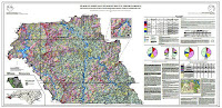
2006 Jackson County. NC Slope Evaluation Map
Green indicates 30-50% slopes; purple 50-100% |
Jackson County, NC Mountain Real Estate
Absent landslide hazard maps, Jackson County planning board members were able to conclude by use of soil survey documentation that requests for steep slope building permits should be carefully considered due to the region's unstable land conditions. As stated by the Board, approximately one half of Jackson County land is either severely constrained (30-40% grade) or unsuitable ( > a 40% grade) for future development. For clarification, please see page 23 of the Jackson County Land Development Plan.
Western North Carolina Real Estate: Landslide/Soil Hazard Disclosure
Decades ago, federal soil experts cautioned Western North Carolina planning boards that mountain slope development on or above a 15% grade was not advisable.
Western North Carolina County Soil Survey reports find that the region's steep slope soils are "ill-suited" for building sites because they require “major increase in construction effort, special design, or intensive maintenance.” In other words, earth movement is
expected.
Homeowners face these identifiable hazards without protection: landslide insurance is not purchasable.
In May 2010, the North Carolina Real Estate Commission acted to protect purchasers: Realtors and developers must disclose hazardous-land data in mapped counties. The following archived article discusses the reason for the Commission's material fact ruling.
Realtors, developers grapple with the implications of disclosure req's for landslide hazard maps
Macon County News— June 17, 2010— Christopher Carpenter
At a meeting of the Franklin Board of Realtors in May, many area realtors learned for the first time that the information on the Macon County Landslide Hazard Maps developed by the North Carolina Geological Survey represents a material fact and as such falls under disclosure requirements when listing or selling property in the county.
The hazard maps, completed in 2006, have been available to realtors and the public since then. Still, several at a May 20 meeting were surprised to learn that attorneys at the North Carolina Real Estate Commission have deemed the information a material fact.
Since the announcement of the requirements, concern has risen among realtors, developers and property owners about the potential negative impacts on real estate transactions in the county. There is concern that buyers will be frightened off by the disclosures or that realtors will hesitate to recommend certain properties. More generally, there seems to be confusion over exactly what and how to disclose the information.
"I think there needs to be more education on exactly what the realtors need to be doing about this whole situation," said Evelyn Owens. "The fact is, we have those slide maps-it is a material fact-we, by law, have to disclose that to potential buyers when they are looking at property or houses that just happen to be in that hazard area."
The problem, said Owens, a member of the Board of Realtors and owner/broker of Keller Williams in Franklin, is that realtors in Macon County are still figuring out what the maps are telling them. "No one has had any education on how to go about explaining it," she said.
Jamie Stamey, a realtor with Unique Properties of Franklin, echoed Owens' opinion, saying, "There needs to be more education and better understanding of what the maps are showing and how to explain them."
The current landslide hazard maps "are pretty vague in terms of what we're showing," added Stamey. "You can tell approximate areas, but it is hard to identify certain properties within those areas."
"North Carolina has deemed it a material fact if it's on a steep slope, but we need a better way to determine exactly. For instance, if you've got a 40 acre tract of land, the top 20 acres could be in that steep slope hazard [area] and the bottom 20 is not," explained Stamey.
John Becker, with Exit Smokey Mountain Realty in Franklin, feels that the discussion about the maps is premature. "They're telling us that this is a material fact now, but we don't know how to define what the material fact is because we don't know exactly what these things entail," he said.
"Everything up to this point is conjecture," said Becker, who is also a member of the planning board subcommittee in the process of developing a safe slope ordinance for the county. "All the maps, all the different information that's out there is scientifically sound," but the interpretation and the application of those things have yet to be determined, Becker said.
In addition to a lack of knowledge about the landslide hazard map, the state has yet to produce any forms or publish protocol to guide realtors in disclosing the information. In contrast, instruments for flood hazards and property within federally designated flood plains have been available for years.
"We do not have any paperwork," Owens complained. "For every other disclosure that we have, we have paperwork."
"We were the first county to get the maps," she continued, but "the attorneys on the Real Estate Commission, they haven't provided us with any documentation to disclose that."
History of the Landslide Hazard Map
The creation of the landslide hazard maps was authorized by the Hurricane Recovery Act of 2005, established by the state as a result of the damage and destruction caused by landslides after hurricanes Francis and Ivan in 2004. A landslide at Peeks Creek in Macon County destroyed homes and left five people dead.
"The Peeks Creek debris flow was, as far as we know, the most serious and deadly landslide event in those parts," said Rick Wooten. Wooten, a geologist from the North Carolina Geological Survey (NCGS), helped develop the map for Macon County. He says the Peeks Creek slide was the key event that brought the issue to people's attention.
Prior to the slide, the NCGS had already been involved in some investigations in the region, identifying a number of specific historical landslide events, but, says Wooten, it had not planned the scope of mapping approved later by the legislature.
The legislature mandated the mapping of 19 counties that had been declared disaster areas after the hurricanes of 2004. At this point, three counties in Western North Carolina have had landslide hazard maps completed by NCGS. Macon County was the first, Watauga second, and Buncombe third. Wooten reports that the mapping project for Henderson County has been mostly completed and that Jackson County will be the next project.
The process takes time. "We combine a lot of information ... and use it to give us the best picture we can get of potential landslide hazard areas," said Wooten.
To understand how the landscape is changing over time, the project for Macon County utilized aerial photography from 1954, 1993, and 1998 and satellite imagery from 2004. Also used were high resolution topographical maps-called LiDAR maps for Light Detecting and Ranging-which had been developed for the flood plain mapping program. These maps provided detailed information about the ground surface, particularly slope, which is a key component of the analysis.
"That is the first thing we do to pinpoint areas to visit in the field," Wooten explained. "We then go to specific locations-targeted areas-where we want to verify what we've found in the imagery and on the LiDAR maps."
"It's a combination of remote sensing and boots on the ground, with a fairly sophisticated computer analysis from a program designed specifically to analyze broad areas for slope stability," Wooten said.
While he says the mapping process is rigorous, Wooten is quick to add that the maps are to be used simply as a planning tool.
"It doesn't substitute for site-specific, on the ground investigation by a qualified geologist or engineer to asses the stability of a specific site," he said. "That's very dependent on the conditions at that site. And even at the site scale, a scale of a quarter acre parcel for instance, conditions can vary considerably even in an area that small. Our view is that these maps show areas where that level of investigations is warranted or even recommended before development."
The NCGS determined that 26 percent of Macon County lies within high or moderate hazard areas; 11 percent is designated high hazard area, but those are mostly on Forest Service lands which is also where most landslide deposits have been documented.
Will disclosure impact investment in the county?
Several realtors and developers have expressed concerns over the impact that disclosure requirements may have on investment and land values in the county. Understandably, it is a sensitive topic for realtors that see a need to balance issues of public safety and economic vitality but do not want to be seen as overly concerned with their bottom lines.
"The economy has affected all of us," said Owens, who is also a member of the Macon County Planning Board. Compliance with material fact disclosure requirements is not optional, said Owens, but she is concerned that a negative impact on real estate will mean a negative impact on the whole economy of the county. Real estate is "the industry for Franklin," she explained. Buyers of second homes in the county also "spend money that supports the local businesses, whether it's carpet layers or people working in restaurants or selling tires or whatever."
"I do not know the solution, and I think there needs to be a lot of education," Owens said, "but a lot of people are really concerned about how this is affecting their livelihood."
While Stamey also sees the benefit of educating developers and buyers about the hazards of building in the mountains, he feels the new requirements are being instituted at a poor time.
"It's a tough time to institute something like this," he said. "They did this at a time when we're in our most depressed situation." Stamey added that the construction industry has been hit particularly hard.
Stamey says he sees very little new development happening in the county in the near future. "We probably have a ten or 20-year supply of vacant lots sitting on the market right now," he said. "Banks are not wanting to finance land, so land sales are by far the worst we've ever seen."
But Stamey believes that home sales will also be affected, particularly more expensive homes with mountain views.
Another local realtor, who asked to remain anonymous, said that his business had already been affected by the disclosure requirements. The realtor says he personally lost a recent sale because the house he was selling was in a downslope landslide hazard area. He is concerned that the maps may exaggerate the danger for potential buyers.
"I understand that safety is their number one issue with [the map]," he said. "I just feel like it's a little overboard."
At the same, as other realtors have said, he feels authorities have done a poor job in educating the public on the maps and how to use them.
"How is it going to affect me?" he asked. "Of course, it's going to affect my pocket, but at the end of the day I'm not so worried about it. I think the key to it as a realtor is knowing how to present it to your clients and help them understand it."
Local businessman and property developer Bill Vernon is also concerned that the map exaggerates the real danger of landslides in the county and will have a chilling effect on real estate. He is also afraid that it will be very difficult to convince buyers that a property is safe if it falls within a hazard area on the map.
"Even though landslides like Peeks Creek may only occur every few thousand years or so, you have to live with the map designation they assigned you today," he said.
Not everyone is worried about the map, however.
"Absolutely not," said Becker when asked if he felt the existence of the maps would have a negative impact on his business. "My opinion is that when you look at those maps and see what they're showing, all you have to do is look at the history of the county and say, you know what, this thing has been here for 10,000 years, and it's been the same."
"If you look at those maps and see the red coming down, you say to your clients, 'I'm not saying that you can't build there, but it would be prudent to have an engineer take a look at it to see what you can do to make sure you're on stable ground.'"
Becker is confident in the value of the information provided on the maps, but he agrees that it will take time to educate realtors and the public on how to interpret it. The objective is public safety, he says.
"That's what this is all about. ... We want to sell properties, we just want to do it and make sure that everyone is safe."
When asked if he thought the landslide hazard map exaggerated the dangers of landslides, Wooten admitted that it is possible. Still, he believes the benefits of the project outweigh the drawbacks.
"Is there the potential that it maybe raises more concerns than are warranted? There may be in some cases," he said. "But ... it works both ways. That's why we emphasize that this is a planning tool so that resources can be applied in the areas where they are most probably needed."
Wooten says the NCGS is a neutral party that produced the maps so that people can make informed decisions about development on slopes, whether they be realtors, private sector geotechnical firms or members of the general public.
Likewise, Wooten stressed that the maps don't designate areas that cannot be developed.
"It doesn't mean that you can't build there, but it just means that, based on the information that's available, it makes sense to site, to design and build carefully in this area," he said. A project in a high hazard zone could get a stable location simply by moving the house pad or the road over 15 or 20 feet, he said.
Wooten recommends that builders always be cognizant of what is underneath them. "You want to know what you are building on. The leaning tower of Pisa is built on land as flat as a pancake."
To criticism that the map is too general, Wooten argues that this is one of its benefits.
"No, it is not site specific, but on the other hand, what it does give you is the big picture. It tells you what is above your site that could impact where you develop and how you develop. It also tells you what is below you so that if things don't go as planned and you have problems, you might be affecting those areas. So it gives the design professional the big picture, which goes beyond what the site specific investigations do."
Be that as it may, many realtors are still grappling with what the map means in terms of their businesses. At the same time, progress is being made on a safe slope development ordinance, which may also take some adjustment within the development and real estate industries.
"We want everybody to use their land the way they want," said Becker about work on the ordinance. Becker says the landslide hazard map project is similar to the previous project to map the flood zones in the state.
"We have certain types of technology now that we didn't have ten, 20 years ago," he explained. "There's property now that is right in the flood flow that we didn't know before. That kind of property is in danger."
Owens agrees that the issue of landslides is important and that safety is the priority. "I just hope that we can all work through this and have a good plan in the end that's not going to affect anybody's livelihood in a negative way."


